|
|

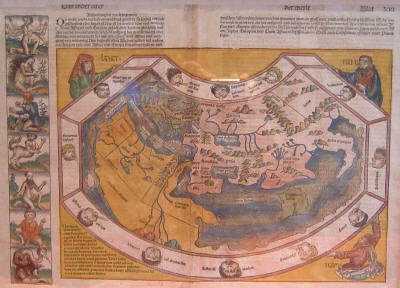
PTOLEMAIC VIEW OF THE WORLD
This map shows the world as it was known prior to the discoveries of the Americas. It was first published in Latin in July 1493, before Europe knew of Columbus' first voyage. (The image shown above is from the second, German, edition published in December 1493.) The map is based on Ptolemy's Geography, which was written in the second century A.D., and continued to be the best single reference on the geography of Europe and Asia available in 15th Century. This is a traditional Ptolemaic map. Although Bartolomeus Diaz had recently sailed around down Africa's Atlantic coastline, around the Cape of Good Hope and into the Indian Ocean, the Indian Ocean is still shown as landlocked. India is an undersized distorted hook pointing downward and located near the eastern edge of the ocean. The large (green) island in the middle of the Indian Ocean is Taprobana, now known as Ceylon, oversized and misplaced: It actually lies off the south east coast of India. Scandinavia and the Far East are not shown, though both were certainly known: Marco Polo traveled to Kublai Khan's China in the 13th Century. The three larger figures around the map's frame are Shem, Japhet and Ham, the sons of Noah who repopulated the world after the biblical flood. The twelve smaller figures are the heads of the twelve winds. Approximately 2,500 of the world maps were printed (1,500 Latin and 1,000 German). The Liber Chronicarum, also known as the Nuremberg Chronicle after its place of publication, was a history of the whole world from creation. It included a variety of fanciful stories and illustrations, including the seven to the left of the world map. From top to bottom, these are a six armed man, a woman covered with long hair, a man with six fingers on each hand, a creature that is a man from the waist up and a horse from the waist down, an hermaphrodite, a four-eyed person, and a man with a bird-like elongated neck and beak. David Kalifon World Map [woodcut 30.5 cm high x 43 cm wide, from Liber Chronicarum, Hartman Schedel (author); Michael Wolgemut and Wilhelm Pleydenwurff (illustrators); Anton Koberger (publisher), Nuremberg, 1493]. Illustration courtesy of a Society member. |