|
|

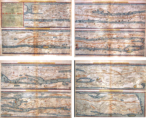
ROMAN ROAD MAP FROM 4TH CENTURY C.E. This 1624 work by Ortelius ultimately derives from a Roman road map drawn on a papyrus scroll about the 4th century A.D. Although the original has been lost, the map is known through a parchment copy created in the 12th or early 13th century, discovered about 1500 by the humanist Konrad Celtes of Vienna, and bequeathed in 1508 to Konrad Peutinger. If the eight strips on Ortelius' four sheets were cut and pasted end to end, they would recreate the original 7-1/2 inches high and 13-1/2 feet long scroll. Ortlelius printed about 300 copies of this map. The map extends from what is now England in the northwest to what is now Ceylon (off the coast of India) in the southeast and shows roads and distances between "staging areas". The staging areas appear as offsets (or zig-zags) on the roads. Distances are recorded as Roman numerals and generally represent Roman miles [1.5 km]. At times local measurements are used, such as leagues are used in Gaul and parasangs in Persia. There are about 70,000 Roman miles of roads and 3,500 place names of cities, towns, baths, forests and other landmarks. The map's three principal cities are Rome (with Ostia, its port), Constantinople (known as Bynzantium prior to 330 AD), and Antioch. David Kalifon "Tabula Itineraria Ex Illustri Peutingerorum Bibliotheca . . . Marco Velsero . . . 1598." [Engraved, each sheet 20 cm high x 52 cm wide, published in Paregon by Abraham Ortelius, 1624.] Image courtesy of Society member. |