|
|

EARLY LOS ANGELES
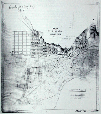
The 1849 Gold Rush brought a flood of new immigrants to California. Los Angeles' cash-poor city fathers saw an opportunity to sell land within their pueblo to these newcomers. Since the pueblo's founding, real estate had often been transferred by a handshake between friends, no longer practical with this new influx. The city fathers contacted the Military Governor of California, Colonel Bennet Riley, for advice. He strongly recommended that a city map be drawn to formalize land transactions and prevent future conflicting claims. Governor Riley suggested that the map-making contract be given to Army Lieutenant Edward 0. C. Ord. Army officers were feeling the pinch of inflation caused by the Gold Rush, and outside jobs were encouraged. The Ayuntamiento or City Council accepted the suggestion and hired Ord for $3,000. The survey was accomplished by Lt. Ord and his assistant, William Rich Hutton, during July and August 1849. Ord's map laid out streets and city lots in an area five blocks north of the Plaza and as far south as present-day Pico Boulevard. This was a fraction of the original four square leagues (about 25 square miles) granted to the pueblo by the Spanish government in 1781. Yet the map covers the heart of today's Los Angeles and set the pattern for the city's growth. Ord's westernmost street was "Grasshopper Street" (now Figueroa Street). East of Main Street lay cultivated fields to the banks of the Los Angeles River. Near the middle of the map lay the Zanja or water supply ditch for the town. The map is oriented with northwest at the top. The City Council was delighted. The map sparked the first Los Angeles real estate boom as lot auctions filled the city's treasury. Ord left a legacy of names on newly plotted streets, including Spring Street, named for his then current sweetheart Trinidad Ortega, his Primavera-or"Springtime." Central Los Angeles streets were laid out parallel to then existing South Main Street. However, it was North Main Street, at approximately 22 degrees east of true North, which later streets within the boundaries of the original pueblo would parallel. Beyond Hoover Street, 2-1/2 miles (two leagues) west, and Indiana Street, 2-1/2 miles east of the Plaza, most streets run due north and south, today clearly showing the limits of the original pueblo. Bill Warren Plan De La Ciudad de Los Angeles. Surveyed & Drawn by E.O.C. Ord Lt USA & Wm R Hutton Asst. August 29th 1849 Scale of 10 inches to the Mile. [Manuscript, early copy of the original, 73.5 x 77.5 cm.] From Warren Heckrotte (Ed.) & Julie Sweekind (Ass't Ed.), California 49 [/] Forty-nine maps of California from the sixteenth century to the present, California Map Society, Occasional Paper No. 6,with The Book Club of California, San Francisco, CA, 1999. Map courtesy of the Huntington Library, San Marino, CA. |