|
|

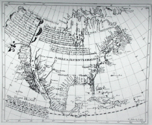
The North part of America Conteyning Newfoundland, new England, Virginia, Florida, new Spaine, and Noua Francia, wth ye riche Iles of Hispaniola, Cuba, Jamaica, and Porto Rieco, on the South, and upon ye West the large and goodly Iland of California... (1630)
Henry Briggs map initiated one of the most famous of all cartographic misconceptions, California as an island, which persisted until the end of the seventeenth century. This idea is thought to have originated with the Carmelite friar, Antonio de la Ascension who accompanied Sebastian Vizcaino on his West Coast expedition of 1602-03, and wrote an account of the trip. About 1620, it is believed that Father Ascension drew a map depicting California as an island and dispatched it by ship to Spain. The ship was captured by the Dutch and the chart taken to Amsterdam. In 1622, California appeared as an island on two title page vignettes published in Amsterdam by Michiel Colijon: Jacob le Maire's Spieghel Der Australische Navigatie and Antonio de Herrera's Descriptio Indw Occidentalis. That same year in London, Henry Briggs, a leading English scientist, published an article entitled "A treatise of the Northwest Passage to the South Sea, through the Continent of Virginia, and by Fretum Hudson." Briggs claimed to have seen a map in London brought from Holland showing California as an island. His article was republished slightly modified in 1625 in Purchas' Pilgrimes, and was accompanied by this map supposedly drawn from the one "taken by Hollanders." A similar map engraved by Abraham Goos was inserted into a small book published in 1624 in Amsterdam. Although dated earlier, it is likely that this map used the Briggs map as a source. Briggs' map quickly became a model for others. John Speed copied it in 1626-7 as did Joannes Jansson in 1638, and soon nearly all European cartographers depicted California as an island. One purpose of the map was to suggest the probability of a short passage from Hudson Bay to the Pacific Ocean, which was enhanced cartographically by the absence of a northern coast and land to the west, which were common features of maps up to that time. Glen McLaughlin The North part of America Conteyning Newfoundland, new England, Virginia, Florida, new Spaine, and Noua Francia, wth ye riche Iles of Hispaniola, Cuba, Jamaica, and Porto Rieco, on the South, and upon ye West the large and goodly Iland of California... R. Elstracke, Sculpsit. [Engraved, 26.7 x 33.9 cm. Published in Hakluytus post humus or Purchas his Pilgrimes by Samuel Purchas, London, 1625.] Image courtesy of a Society member. From Warren Heckrotte (Ed.) & Julie Sweekind (Ass't Ed.), California 49 [/] Forty-nine maps of California from the sixteenth century to the present, California Map Society, Occasional Paper No. 6,with The Book Club of California, San Francisco, CA, 1999. |